
| Key Takeaways • Ground sample distance (GSD), not megapixel count alone, is the primary factor that determines how accurately an aerial map can be measured. • Published photogrammetry standards, including ASPRS’s Class 1 accuracy class, tie required horizontal and vertical accuracy directly to the GSD of the source imagery. • Combining near-infrared and RGB capture into a single aerial pass (4-band imagery) has been reported to cut data acquisition time by roughly 40% versus flying separate sensor passes. • Independent aerial survey operators who adopted larger-format aerial camera systems have published case studies reporting higher order volumes and improved profitability. |
What does ground sample distance actually measure in an aerial mapping project?
Ground sample distance (GSD) is the real-world size, in centimeters, that a single pixel represents on the ground once an aerial image is captured. It is set by flying height, lens focal length, and sensor pixel size together, not by megapixel count alone, and it is the number that ultimately limits how small a feature a survey can resolve or how precisely a point can be measured. Two cameras with very different resolutions can still deliver the same GSD if one flies lower or uses a longer lens, which is why GSD, rather than a marketing resolution figure, is the specification photogrammetrists check first. As a rule of thumb, flying higher increases GSD (each pixel covers more ground) while flying lower decreases it, so a survey team weighs altitude against coverage area, flight time, and the accuracy target set for the deliverable before a mission plan is finalized.
How does GSD determine the positional accuracy a map can achieve?
GSD sets a ceiling on positional accuracy because a measurement can only be as precise as the pixels it is derived from, and published mapping standards translate that relationship into concrete accuracy classes. The American Society for Photogrammetric Engineering and Remote Sensing (ASPRS) documents a widely used example under its Class 1 accuracy standard: orthophoto products derived from 15 cm GSD imagery are expected to meet a horizontal RMSE of 30 cm and a vertical RMSE of 20 cm for 2-foot contour intervals. ASPRS’s own published overview of these positional accuracy standards also discusses a proposed alternative that ties accuracy directly to GSD as a simple multiple, shown alongside the classic figure below.
RMSE, or root-mean-square error, is simply a statistical way of summarizing how far a set of surveyed check points typically falls from their true position once a map or model is produced, expressed in a single distance figure rather than a list of individual errors. A smaller RMSE means a tighter, more reliable fit between the finished deliverable and reality, which is why mapping contracts specify a maximum allowable RMSE rather than leaving accuracy to be inferred from the camera specification sheet alone.
| Accuracy basis | How it is defined | Resulting accuracy at 15 cm GSD |
| ASPRS Class 1 (published example) | Fixed accuracy class documented for 15 cm GSD orthophoto imagery | 30 cm horizontal RMSE / 20 cm vertical RMSE (2-ft contours) |
| Proposed GSD-multiple rule | RMSEx = RMSEy = RMSEz = 1.25 x GSD, regardless of sensor or flying height | Approximately 18.75 cm horizontal and vertical RMSE |
Two documented ways of tying photogrammetric accuracy to ground sample distance; both are illustrative examples at a single GSD value, not universal guarantees for every sensor or flight plan.
Why do independent survey operators report efficiency gains after upgrading to larger-format aerial cameras?
Independent aerial survey firms that have moved to larger-format aerial camera systems have published case studies reporting faster data acquisition, higher order volumes, and improved profitability. One European aerial survey operator using a 190-megapixel aerial camera system reported a 25% increase in profitability and a 2.3-times increase in survey-mission orders compared with the previous year, while another operator running a hybrid two-camera setup reported roughly 40% faster four-band data acquisition. A third operator noted that a larger single-frame sensor let their crews fly higher and faster while still acquiring larger images in about two-thirds of the previous flight time.
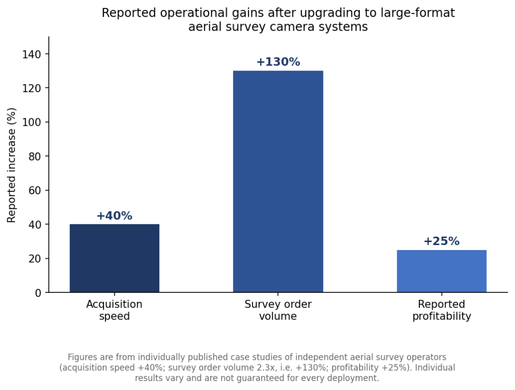
Reported operational gains from published case studies of independent aerial survey operators after adopting large-format aerial camera systems.
Why does the physical size of the camera sensor change how a mapping flight is planned?
A larger single-frame sensor captures more ground area in every exposure, which directly reduces the number of flight lines and passes needed to cover the same survey area at a given GSD. Published case studies describe aerial camera systems spanning roughly 100 to 280 megapixels being deployed for different mapping scales, from a hybrid two-camera 100-megapixel setup used for combined multispectral and RGB acquisition to a single 190-megapixel system credited with the profitability and order-volume gains cited above. One operator flying a 150-megapixel aerial camera reported that the larger sensor let their crews fly at higher altitudes and faster speeds while still acquiring larger individual images, cutting the time needed to cover a given survey area to roughly two-thirds of what it took previously. In practice, that means a larger-format sensor is less a resolution upgrade than a coverage-per-flight-line upgrade, which is what ultimately shows up as fewer flight hours, lower fuel and crew cost, and faster turnaround for the same accuracy target.
What can 4-band aerial imagery add to a standard RGB mapping flight?
4-band aerial imagery adds a near-infrared channel to the standard red-green-blue capture in a single pass, which is what allows one flight to serve both visual mapping and vegetation- or moisture-sensitive analysis. Combining NIR and RGB acquisition in one sensor pass is also the specific change behind the roughly 40% faster acquisition time reported above, since it removes the need to fly a separate multispectral or near-infrared sensor pass over the same area. a closer look at the aerial camera systems built for these combined-band missions covers how that single-pass capture is configured in practice.
What applications actually depend on this level of aerial mapping accuracy?
Engineering-grade aerial mapping accuracy supports applications where a few centimeters of error changes a real-world decision: 2D and 3D city modeling, digital elevation models (DEMs) and orthophoto production, precision agriculture and forestry analysis, oil and gas pipeline route planning, and wetland boundary identification. Each of these deliverables inherits whatever positional accuracy the source GSD and flight plan can support, which is why the accuracy class is typically specified before a mapping contract is scoped rather than checked after delivery. an overview of aerial mapping and surveying workflows covering these use cases walks through how flight planning, ground control, and camera selection are matched to a given accuracy target. A separate resource on the flight-planning and mapping software used to manage these missions describes how flight lines, overlap, and camera triggering are coordinated to hit a target GSD across an entire survey area.
Reaching a specified accuracy class also depends on more than the camera: flight lines are typically planned with substantial forward and side overlap between consecutive images so that every ground point appears in several frames, and independently surveyed ground control points are used to tie the resulting model to a known coordinate system rather than relying on GPS positioning alone. Skipping either step tends to show up later as a mismatch between the accuracy a camera and GSD could theoretically support and the accuracy the finished orthophoto or elevation model actually delivers, which is why accuracy specifications in mapping contracts typically cover the full workflow rather than the sensor in isolation.
Frequently Asked Questions
What is ground sample distance in aerial photogrammetry?
Ground sample distance is the real-world size, typically measured in centimeters, that a single pixel of an aerial image represents on the ground, and it is set by flying height, lens focal length, and sensor pixel size.
Does a higher-megapixel aerial camera automatically produce a more accurate map?
Not on its own; megapixel count matters only to the extent that it affects the achievable ground sample distance at a given flying height, so two cameras delivering the same GSD produce comparable base accuracy regardless of their raw resolution.
How is 4-band aerial imagery different from standard RGB aerial photography?
4-band imagery adds a near-infrared channel to the standard red-green-blue capture within the same sensor pass, enabling vegetation- and moisture-sensitive analysis without a separate flight.
What accuracy standard should a mapping deliverable meet for engineering-grade work?
ASPRS’s published Class 1 standard is a commonly referenced benchmark, documenting a 30 cm horizontal and 20 cm vertical RMSE example for orthophoto products derived from 15 cm GSD imagery.
