
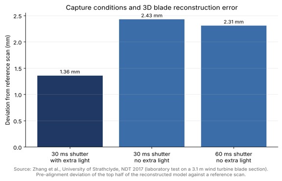
| Key Takeaways • Drones inspect wind turbine blades because the blades are high on towers and often in isolated places, and remote inspection can reduce operating and maintenance costs. • Blade inspection needs millimeter-scale detail, and ground sample distance depends on pixel size, focal length and standoff distance, not megapixels alone. • In a University of Strathclyde laboratory test, a 30 ms shutter with added light gave a 1.36 mm reconstruction deviation, against 2.43 mm without added light. • Position data and constant-distance flight paths help turn blade images into findings that can be tracked and compared over time. |
Why are wind turbine blades inspected by drone?
Wind turbine blades are inspected by drone because they sit high on towers, often in isolated places, which makes them difficult and costly to reach by other means. Researchers at the University of Strathclyde note that visual inspection is regularly used as a method of non-destructive testing for large structures, and that remote inspection of blades can reduce operating and maintenance costs and extend asset life. A practical example is a published case study on imaging blade fissures, in which the drone maker ATI flew a 100 MP camera on its Thor octocopter to find and photograph fissures on a blade that had been marked and measured two years earlier. According to the write-up, the inspection finished within two hours, and three blades were inspected in only 45 minutes.
What image detail does a blade inspection need?
A blade inspection needs millimeter-scale detail, because early cracks, fissures and surface damage are small compared with a blade several tens of meters long. The ATI case study reports millimeter-per-pixel detail from the aerial imagery, and the same account says clients were impressed by the resolution when reviewing the images. Sensor resolution alone does not deliver that detail. Ground sample distance depends on the pixel size, the focal length and the standoff distance between the drone and the blade, so a high-resolution camera flown too far away still produces coarse results. Operators comparing inspection camera options for powerlines, wind turbines and pipelines should therefore ask what GSD a given payload delivers at the standoff distance the site actually allows.
How do shutter speed and lighting affect inspection results?
Shutter speed and lighting affect inspection results by controlling motion blur and brightness, and a controlled laboratory test shows the effect clearly. In the Strathclyde work, a small UAV captured about 600 images of a 3.1 m blade section, and the team measured how closely a 3D model built from those images matched a reference scan. With a 30 ms shutter and added lighting the deviation was 1.36 mm, while the same shutter without added light gave 2.43 mm and a 60 ms shutter without added light gave 2.31 mm. The authors conclude that both light intensity and motion blur affect the reconstruction, and that shortening the shutter reduces blur but also reduces brightness, so the two have to be balanced. The full paper is open for readers who want the method.
Which payload factors matter most for blade inspection?
The payload factors that matter most are the GSD achievable at a safe standoff distance, control of motion blur, dynamic range across bright sky and shaded blade surfaces, and reliable position data for each image. The table summarizes why each factor matters and what to ask of a payload before a campaign.
| Factor | Why it matters | What to check |
| Resolution and GSD | Cracks and fissures are small, so millimeter-per-pixel detail is needed. | GSD at the real standoff distance, not the best-case figure. |
| Shutter and motion blur | Motion blur destroys image information and breaks 3D reconstruction. | Shortest usable shutter time and stability of the platform. |
| Lighting and dynamic range | Short shutters reduce brightness, and blades mix bright and shaded surfaces. | Sensor dynamic range and performance in low light. |
| Position and location data | Findings without location are hard to evaluate and track over time. | Whether each image carries position data for mapping to the blade. |
| Flight path | A constant distance from the blade limits blur and keeps focus on the surface. | Waypoint or guidance support for repeatable scan paths. |
The Strathclyde authors point to the last two items directly: they note that approaches which detect defects in offline pictures do not provide position and location information, which is useful for credible surface condition evaluation, and they use a waypoint guidance algorithm to hold a constant distance and minimize motion blur.
How is blade imagery turned into a maintenance decision?
Blade imagery becomes a maintenance decision when photogrammetry software turns the overlapping images into a 3D model or a mapped image set that an engineer can inspect for defects. In the Strathclyde test, photogrammetric software processed the captured images into a textured 3D blade model in which dust, markings and a discontinuity on the leading edge could be recognized, and the authors concluded that remote photogrammetric inspection of a blade is achievable. The results come from an indoor laboratory setup with motion capture positioning, so field programs still need to validate their own capture settings, weather limits and flight paths. Teams planning repeat inspections should store each campaign’s images with position data, so that a fissure found in one year can be located again and compared in the next, which is the same logic behind revisiting a blade that was marked and measured two years earlier.
How does a payload connect to the drone and the inspection workflow?
A payload connects to the drone through a mechanical mount, a power and data interface, and software that triggers the camera and records position data. One documented example is the integration of Phase One’s P3 payload with the open drone ecosystem of the software company Auterion: the payload is built around a 100 MP iXM camera with a backside illuminated sensor, and the announcement says the pairing can scale high-value, high-risk and time-critical inspections, including wind turbine fields. The announcement, published by Amerisurv, describes the goal of feeding inspection data into existing applications and workflows. Whatever payload is chosen, confirm that the drone’s gimbal, battery budget and flight controller support it, and that image files and position records reach the engineers who review them.
Are the same methods used for other infrastructure inspections?
Yes, the same capture principles apply to powerlines, pipelines, bridges and other structures, because each needs close, sharp imagery taken at a safe distance. The inspection page cited above lists powerlines, wind turbines, pipelines and agriculture as typical drone inspection uses, and the camera manufacturer also publishes bridge inspection work captured from about 130 feet. Blade work is distinctive mainly because of the geometry: a long, curved, moving surface demands a controlled flight path and careful exposure settings, which is why the Strathclyde team built a waypoint scan around the blade rather than flying a straight line.
Frequently Asked Questions
Why use a drone to inspect wind turbine blades?
Blades are high on towers and often in isolated locations, so drones offer a way to capture close visual data without climbing, and remote inspection can reduce operating and maintenance costs.
What resolution is needed for wind turbine drone inspection?
Inspectors need millimeter-scale detail to see fissures and cracks, which depends on sensor resolution, focal length and standoff distance together, not on megapixels alone.
How does shutter speed affect drone inspection images?
A shorter shutter reduces motion blur but also reduces brightness, and a university laboratory test found a 30 ms shutter with added light gave the most accurate 3D reconstruction.
Can drone photos be used to build a 3D model of a blade?
Yes, photogrammetry software can turn overlapping drone images into a textured 3D model in which surface defects are recognizable, as shown in a University of Strathclyde study.
