
| Key Takeaways • Situational awareness is the perception of elements in an environment, the comprehension of their meaning and the projection of their near-future status, a model set out by Mica Endsley in 1995. • The three levels build on one another, so an error at the perception level carries through to comprehension and projection. • Thermal imaging uses the mid-wave infrared band of about 3 to 5 micrometers and the long-wave band of about 8 to 14 micrometers, and detects emitted heat rather than reflected light. • Better imagery alone addresses only the first level, so effective situational awareness also depends on timely delivery of video and reliable support for understanding and anticipation. |
What is situational awareness?
Situational awareness is the perception of elements in an environment within a volume of time and space, the comprehension of what those elements mean, and the projection of their status in the near future. The definition comes from human factors researcher Mica Endsley, whose 1995 paper in the journal Human Factors set out the model that most later work builds on. It was developed for operators of dynamic systems, and it now underpins the design of control interfaces, autonomous systems and safety-critical operations. In a military setting the idea is the same but the stakes are different, because the elements being perceived are people, vehicles and threats that move and react. A useful overview of the concept is available from the IEEE Technology Navigator entry on situational awareness, and a practical treatment of how it plays out in the field is covered in this discussion of decision-making support in high-risk environments.
What are the three levels of situational awareness?
The three levels are perception, comprehension and projection, and each depends on the one below it. An operator who misperceives a sensor reading will form a wrong comprehension, and a wrong comprehension will produce a flawed projection. The framework is summarized in the table below.
| Level | Name | What it means in practice |
| Level 1 | Perception | Detecting and monitoring the status, attributes and dynamics of elements in the environment |
| Level 2 | Comprehension | Understanding what those elements mean in relation to the mission and to each other |
| Level 3 | Projection | Forecasting how the situation will evolve if no action is taken |
A paper prepared for the test and evaluation community describes these as three states of cognitive processing that occur iteratively and feed a decision about what to do next. That cyclical quality matters for design, because the picture is always changing. A practical example is urban combat, where perceiving, understanding and anticipating threats in dense environments is the central challenge. The model is explained further in the ITEA paper on measuring situation awareness in operational testing.
Which sensors support the first level of situational awareness?
Visible-light cameras and infrared cameras support the first level by covering different parts of the spectrum, and the combination gives an operator usable imagery day or night. Infrared imaging is usually divided into short-wave (SWIR, about 1 to 2.5 micrometers), mid-wave (MWIR, 3 to 5 micrometers) and long-wave (LWIR, 8 to 14 micrometers) bands, according to the IEEE Technology Navigator. The atmosphere transmits well in windows at 3 to 5 and 8 to 14 micrometers, and LWIR is the most common choice for terrestrial thermal imaging because it aligns with the peak emission of objects at ambient temperature.
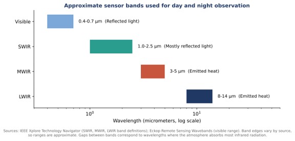
The physical difference explains the operational difference. SWIR forms images mostly from reflected light, much like a visible camera, while MWIR and LWIR detect heat radiated by objects themselves and therefore work in total darkness. Vendors build products around this principle in different ways. Maris-Tech, for instance, describes its military surveillance product line as combining day and thermal imaging with AI analytics. The band definitions are laid out in the IEEE Technology Navigator page on infrared imaging.
How do MWIR and LWIR cameras differ in practice?
MWIR and LWIR cameras both image emitted heat, but they differ in detectors, cooling and typical use. Remote sensing references note that indium antimonide detectors are commonly used for MWIR and mercury cadmium telluride for LWIR, while microbolometer image sensors are used primarily in the LWIR band. Uncooled LWIR microbolometers are the common, simpler option, and cooled detectors are the more specialized one. An optics manufacturer’s buyer guide adds that MWIR delivers strong thermal contrast against hot targets and is usually cooled, while LWIR is the most widely deployed thermal band. Neither is universally better, and the choice depends on target, range, environment and cost.
How does coverage change what an operator can comprehend?
Wider coverage helps comprehension because it removes blind spots that force an operator to guess, but it also increases the amount of imagery that must be processed. A system that provides 360 degree 3D coverage can present a continuous panoramic picture, and Maris-Tech lists that kind of coverage among the features of its situational awareness products. The benefit is only realized if the video reaches the operator quickly and in usable form, since a stale picture produces a stale projection at the third level. For that reason encoding, transmission and on-device analysis are part of situational awareness design, and not an afterthought.
How do the three levels connect to decisions and action?
The three levels feed a decision, the decision leads to an action, and the action changes the environment, which starts the cycle again. A security-industry analysis of Endsley’s work describes this loop as perception, awareness, decision, performance of actions, a changed environment and then perception once more. The same analysis warns that when awareness is faulty or incomplete, wrong decisions can follow and the wrong actions can make the situation worse. A guideline from the North American Electric Reliability Corporation, written for power grid operators but built on the same model, defines comprehension as a synthesis of perceived information that goes beyond simply being aware of it, and projection as the ability to anticipate future conditions at least in the near term in order to make informed decisions. That a power-grid guideline and a test-and-evaluation paper for defense programs both rely on the same three-level model shows how general the framework is.
Why does the third level matter most for decisions?
Projection matters most because decisions are made about what will happen, not about what has already happened. The ITEA paper calls accurate projection the hallmark of a skilled expert, and it is the level that separates reacting to events from anticipating them. Technology can support projection by tracking movement over time and highlighting patterns, but the foundation is still accurate perception and correct comprehension. A situational awareness solution that improves only the sharpness of the image, without improving how reliably the operator understands and anticipates, has addressed one level of three.
Frequently Asked Questions
Who defined the three levels of situational awareness?
Human factors researcher Mica Endsley defined the three levels of perception, comprehension and projection in her 1995 paper Toward a Theory of Situation Awareness in Dynamic Systems, published in the journal Human Factors.
How do the three levels of situational awareness depend on each other?
Each level builds on the one below it. A misperceived element leads to incorrect comprehension, and incorrect comprehension leads to a flawed projection of what will happen next.
Why can thermal cameras see in total darkness?
Mid-wave and long-wave infrared cameras detect heat radiated by objects themselves rather than reflected light, so they do not need visible illumination to form an image.
Which infrared bands are used for thermal imaging?
Thermal imaging mainly uses the mid-wave band of about 3 to 5 micrometers and the long-wave band of about 8 to 14 micrometers, which line up with windows where the atmosphere transmits infrared radiation well.
