In today’s fast-evolving world of geospatial technology, aerial mapping has become essential for industries like surveying, agriculture, and urban planning. Phase One drone cameras lead the charge with their high-resolution imaging capabilities tailored for precision aerial photogrammetry. These innovative solutions empower professionals to capture accurate aerial data, transforming complex mapping tasks into streamlined operations.
Overview of Phase One Drone Cameras
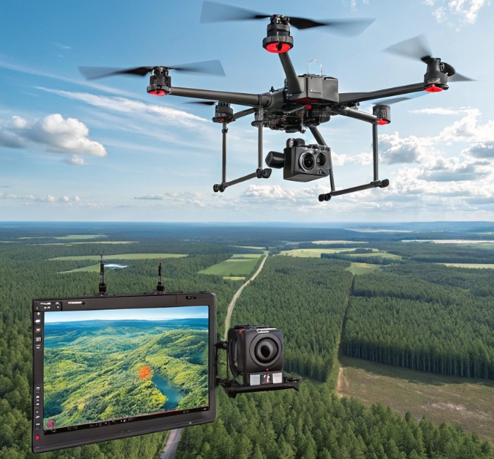
Phase One offers a comprehensive lineup of drone cameras designed specifically for aerial mapping and surveying. Their products, including the 100MP camera, 280MP Aerial Solution, 190MP Aerial Solution, iXM-RS150F aerial camera, and iXM-RS 150MP Camera, focus on delivering ultra-high-resolution images for 2D and 3D mapping. These drone cameras integrate easily with various platforms, supporting photogrammetry processes that yield reliable data for diverse applications.
By combining advanced sensors with multi-spectral capabilities, Phase One enhances aerial mapping efficiency. Their 4-band solutions merge near-infrared (NIR) and RGB imagery, ideal for specialized tasks in agriculture and forestry. Overall, these drone cameras simplify aerial photogrammetry, ensuring high-quality results in challenging environments.
Key Features Highlighted
- High-Resolution Sensors: Options range from 100MP to 280MP, enabling detailed image capture for precision aerial mapping.
- Multi-Sensor Integration: Compatible with LiDAR scanners and avionic systems like SmartBay©, enhancing aerial photogrammetry workflows.
- 4-Band Imaging: Combines NIR and RGB for multi-spectral analysis, perfect for vegetation and environmental aerial mapping.
- Wide Swath Coverage: Allows operations at higher altitudes and speeds, even in low-light conditions, boosting surveying efficiency.
- Digital Data Acquisition: Supports hybrid systems for seamless 2D and 3D mapping outputs.
These features make Phase One drone cameras a top choice for professionals in aerial mapping.
The Role of High-Resolution Imaging in Aerial Mapping
High-resolution imaging is crucial for effective aerial mapping, as it provides the detail needed for accurate geospatial analysis. Phase One drone cameras excel in this area, offering resolutions up to 280MP that capture fine-scale features invisible to lower-end systems. This precision supports aerial photogrammetry by generating clear orthophotos and digital elevation models (DEMs).
In surveying projects, such imaging reduces errors and improves data reliability. Professionals can fly at faster speeds without compromising quality, covering larger areas in less time. Ultimately, this technology elevates aerial mapping standards across industries.
Aerial photogrammetry benefits immensely from these capabilities, allowing for intricate 3D modeling. Phase One’s cameras ensure that every pixel contributes to meaningful insights. This approach minimizes the need for ground verification, saving resources.
Benefits for Precision Aerial Photogrammetry and Surveying
Phase One drone cameras deliver significant efficiency gains in aerial mapping. For instance, they enable 40% faster 4-band data acquisition, reducing flight times considerably. This translates to acquiring larger images in two-thirds the usual time, streamlining surveying operations.
Cost savings are another key advantage, with users reporting up to 25% increased profitability. By diversifying services like in-house GIS development and orthophoto creation, companies expand their revenue streams. Aerial photogrammetry becomes more accessible, fostering business growth.
Reliability shines through in challenging conditions, where high sensitivity allows operations under poor light. No additional flights are needed post-data collection, ensuring project timelines stay on track. Overall, these benefits make Phase One solutions indispensable for modern aerial mapping.
Integration with Drones and Supporting Technologies
Seamless integration is a hallmark of Phase One drone cameras for aerial mapping. These cameras fit into drone systems via platforms like SmartBay©, combining with LiDAR for hybrid setups. This compatibility extends to aircraft, offering flexibility for various surveying scales.
Software support enhances aerial photogrammetry by processing data into usable maps and models. Phase One partners provide turnkey solutions, simplifying the workflow from capture to analysis. Users can rely on these integrations for consistent, high-quality outputs.
In practice, this means drone cameras can handle multi-sensor aerial systems efficiently. Digital data flows directly into photogrammetry software, reducing manual interventions. Such integration boosts productivity in aerial mapping projects.
Real-World Applications in Aerial Mapping
Phase One drone cameras find extensive use in 2D and 3D aerial mapping for geographic information systems (GIS). They support the creation of DEMs, orthophotos, and right-of-way (ROW) mapping for infrastructure like oil and gas pipelines. In agriculture, 4-band imagery aids in canopy analysis and wetland identification.
Forestry applications include 3D modeling for forest regrowth post-deforestation, as seen in studies after hurricanes. Urban planning benefits from digitizing cities and mapping green areas. These drone cameras enable precise aerial photogrammetry in diverse environments.
Large-territory surveys, such as those in Russia, leverage high-resolution capabilities for comprehensive coverage. Multi-level remote sensing for reservoirs and hydroelectric plants further demonstrates versatility. Overall, Phase One enhances aerial mapping across sectors.
Advancing Aerial Mapping with Phase One
Phase One drone cameras continue to push boundaries in aerial mapping and photogrammetry. Their focus on high-resolution, multi-spectral imaging addresses key challenges in surveying. Professionals benefit from tools that deliver accuracy and efficiency.
As industries demand more precise data, these solutions stand ready. Integration with emerging technologies ensures future-proof aerial mapping. Phase One remains a trusted partner for geospatial excellence.
Frequently Asked Questions (FAQs)
What resolutions do Phase One drone cameras offer for aerial mapping?
Phase One provides options from 100MP up to 280MP, including models like the iXM-RS150F and 190MP Aerial Solution. These high resolutions ensure detailed imagery for precision aerial photogrammetry. They support various applications in surveying and mapping.
How do Phase One drone cameras integrate with other systems?
These cameras integrate with LiDAR scanners and avionic systems like SmartBay© for hybrid setups. They are compatible with drones and aircraft, enhancing aerial mapping workflows. Software for photogrammetry processing turns data into usable maps and models.
What are the benefits of 4-band imaging in aerial photogrammetry?
4-band imaging combines NIR and RGB for multi-spectral analysis, ideal for agriculture and forestry. It enables faster data acquisition by 40%, reducing flight needs. This feature boosts efficiency in environmental and vegetation aerial mapping.
Can Phase One solutions handle large-area surveying?
Yes, with wide swath coverage and high sensitivity, they allow operations over vast territories even in poor light. Case studies like Uralgeoinform show increased orders and profitability for large-scale projects. These drone cameras excel in comprehensive aerial mapping tasks.