• Modern aerial imaging technologies are revolutionizing the way utilities maintain, monitor, and protect vast powerline networks.
• As infrastructures age and climate risks rise, powerline inspection demands new levels of precision, safety, and efficiency.
• High-resolution imaging, automation, and AI analysis are enabling a shift from reactive to predictive maintenance.
• Phase One’s advanced aerial camera systems empower inspection teams to capture sharper, faster, and safer data from the sky.
For decades, powerline inspection meant sending crews into hazardous conditions—climbing pylons, navigating helicopters, or walking miles of rugged terrain. Today, aerial imaging has transformed this once labor-intensive and risky process into a high-tech operation that’s faster, safer, and far more accurate. Through innovations in airborne camera systems, AI data processing, and digital twin creation, utilities can now assess entire power networks from the air with millimeter precision.
At the center of this transformation is Phase One, a leader in high-resolution aerial imaging solutions. From wide-area mapping to critical infrastructure monitoring, its systems—like the PAS 880 and PAS 280—combine exceptional image quality with intelligent workflow software to deliver actionable data for inspection and maintenance operations.
Why Powerline Inspection Needs a New Approach
Across the globe, power grids are expanding and aging simultaneously. Extreme weather, vegetation growth, and equipment wear increase the risk of faults and outages. Traditionally, these issues were detected through manual patrols or visual helicopter surveys, methods that are slow, costly, and often dangerous.
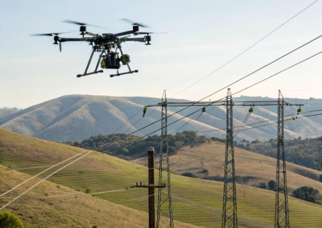
Modern powerline inspection faces a dual challenge: maintaining reliability while protecting personnel. As network complexity grows, utilities are turning to aerial imaging to overcome these limitations. Mounted on aircraft, drones, or helicopters, advanced cameras now deliver real-time, high-resolution imagery that reveals defects invisible to the human eye.
By replacing human inspection at dangerous heights with sensor-driven analysis, aerial imaging reduces risk while increasing efficiency.
How Aerial Imaging Enhances Powerline Maintenance
The key to effective powerline inspection lies in comprehensive, accurate data. High-resolution aerial imagery captures details as small as a loose connector or a damaged insulator, allowing maintenance teams to detect and act before failures occur.
Phase One’s PAS 880 oblique aerial system exemplifies this capability. It integrates multiple 150MP and 280MP sensors, including RGB and NIR channels, to create a complete, multi-angle view of infrastructure. When combined with iX Suite software, the system enables seamless mission planning, flight execution, and post-flight data analysis.
This precision allows operators to:
- Identify hot spots, corrosion, or physical stress before breakdowns occur.
- Analyze vegetation encroachment along right-of-way corridors.
- Generate 3D models of pylons and conductors for digital twin creation.
These insights empower utilities to move toward condition-based maintenance, significantly reducing downtime and operational costs.
Safety Through Distance: Redefining the Inspection Process
One of the most important advantages of aerial imaging is safety. The ability to inspect infrastructure remotely eliminates exposure to high-voltage zones, unstable terrain, and adverse weather.
Systems like the GGS–Siemens Sieaero platform, equipped with Phase One 100MP cameras, showcase the impact of aerial imaging on safe, automated powerline inspection. By integrating RGB, LiDAR, thermal, and ultraviolet sensors into a single multi-sensor head, Sieaero’s helicopter-mounted system captures all necessary data in one pass—up to 100 kilometers of powerlines per day—without a single human climbing a tower.
Each sensor contributes to the overall safety and accuracy of the inspection:
- RGB cameras provide ultra-detailed visuals of structural components.
- LiDAR maps vegetation and measures clearances.
- Thermal and UV sensors detect overheating and corona discharge.
This comprehensive data set enables full situational awareness from a safe distance.
High-Resolution Imaging for Real-Time Decision Making
Powerline inspection isn’t just about collecting images—it’s about understanding what those images reveal. With Phase One’s medium-format aerial cameras, operators achieve real-time visibility into the condition of infrastructure. The cameras’ wide dynamic range ensures clarity even in challenging lighting conditions, such as glare from metallic surfaces or deep shadows under transmission lines.
The PAS 280 system, for instance, provides a cost-effective large-format option with over 20,000 pixels across the swath, ideal for corridor mapping. It delivers both RGB and NIR imagery, enabling combined visual and spectral analysis that highlights vegetation health and conductor temperature differences.
Coupled with intelligent automation in iX Flight Pro, inspection missions can be replanned mid-flight, and images can be reviewed immediately after landing—accelerating decision-making cycles.
Data Integration and the Rise of Digital Twins
Modern aerial inspection workflows rely heavily on data integration. Combining imagery, LiDAR, and AI-driven analysis, utilities can now generate digital twins—virtual representations of entire powerline networks. These twins provide engineers with precise, navigable 3D environments that visualize current conditions and simulate maintenance scenarios.
The Sieaero system, powered by Phase One cameras, embodies this approach. With five synchronized 100MP RGB sensors capturing data from multiple angles, AI models can automatically identify anomalies like cracked insulators, conductor sag, or vegetation overgrowth. Results are consolidated into a digital twin that serves as both a diagnostic tool and a long-term maintenance database.
This convergence of imaging and analytics marks a pivotal step in transforming inspection from a reactive process to a predictive, data-driven strategy.
Aerial Imaging in the Era of Automation and AI
Artificial intelligence has redefined what’s possible in powerline inspection. Algorithms trained on thousands of high-resolution images can now detect defects more accurately and consistently than human observers. When paired with Phase One’s imaging technology, AI systems gain the visual clarity they need for precise assessments.
For instance, Siemens’ automated inspection framework uses AI to interpret imagery from the Phase One 100MP sensors, detecting more than 90% of issues that human operators might overlook. These findings are validated against historical data, allowing utilities to predict failures and schedule maintenance before damage escalates.
By integrating aerial imaging with AI, utilities are achieving a powerful combination of safety, accuracy, and efficiency—transforming inspection into a continuous, scalable process.
Why Phase One Leads in Aerial Imaging for Infrastructure
Phase One’s reputation in aerial imaging stems from a legacy of excellence in optical engineering, sensor precision, and workflow optimization. The company’s camera systems are purpose-built for geospatial applications—designed to meet the unique demands of powerline inspection, mapping, and industrial monitoring.
Each system is characterized by:
- High resolution (up to 280MP) for exceptional detail.
- Bayer pattern sensors that eliminate the need for pan sharpening.
- Blur Control Technology (BCT) to prevent motion distortion at high flight speeds.
- Lightweight construction for longer flight times and reduced fuel use.
Through these innovations, Phase One not only enables more accurate inspections but also ensures that mission efficiency and crew safety are maximized.
The Future of Powerline Inspection Is in the Air
As energy networks expand to meet global demand, maintaining their integrity will require smarter, faster, and safer solutions. The combination of aerial imaging, automation, and AI ensures that inspection teams can cover vast areas, identify risks early, and act decisively—all while keeping personnel safely grounded.
With its commitment to imaging excellence and data integration, Phase One continues to set the standard for aerial imaging in powerline inspection—helping utilities protect the infrastructure that powers modern life.
FAQs
What is aerial imaging for powerline inspection?
It’s the use of airborne camera systems to capture detailed imagery of power infrastructure for maintenance and monitoring.
Why is aerial imaging safer than manual inspection?
It allows crews to inspect from a distance, eliminating the need to climb towers or enter dangerous areas.
How does Phase One’s technology improve inspection accuracy?
Its high-resolution cameras and intelligent software deliver sharp, distortion-free images for precise defect detection.
What are digital twins in powerline inspection?
They’re 3D digital models of infrastructure built from aerial data, used to monitor and predict system health.
Can aerial imaging detect vegetation risks?
Yes. RGB and NIR imaging can identify vegetation encroachment and measure right-of-way clearances.
What’s the advantage of using multi-sensor systems?
Combining RGB, LiDAR, thermal, and UV sensors captures all inspection data in one pass, saving time and cost.
How does AI enhance powerline inspection?
AI analyzes imagery automatically, detecting faults like cracks, corrosion, or overheating with high precision.
What Phase One systems are ideal for aerial inspection?
The PAS 880 and PAS 280 systems deliver exceptional image quality for both wide-area and corridor mapping.
How much faster is aerial imaging compared to manual inspection?
A single mission can cover up to 100 km of powerlines per day, replacing days of manual checks.